

Neighborhoods with MLK streets are poorer than national average and highly segregated, study reveals
- Written by Sweta Tiwari, Post Doctoral Fellow in Geospatial Institute, Saint Louis University
The Research Brief[1] is a short take about interesting academic work.
The big idea
Poverty rates are almost double the national average in areas surrounding streets named after Martin Luther King Jr., according to our recent study[2], and educational attainment is much lower.
Our geography research, published in the GeoJournal[3] in September 2020, analyzed the racial makeup and economic well-being of 22,286 census blocks in the U.S. with roadways bearing the slain civil rights leader’s name. Streets named after Martin Luther King typically run through multiple census blocks; we identified a total of 955 such streets in the United States.
The areas surrounding MLK streets are predominantly African American, with very few white residents, we found. This is particularly true in the South and Midwest. A notable exception includes California, where MLK neighborhoods have seen a recent increase in their Latino population.
Why it matters
American cities began naming streets for the Rev. Martin Luther King Jr. after his 1968 assassination to commemorate the civil rights movement and King’s fight against social inequality[4]. Chicago was the first. In 1968, Mayor Richard Daley renamed 14 miles of Grand Boulevard, in the historically Black South Side[5], as Martin Luther King Jr. Drive.
Today cities in 41 states, Washington, D.C., and Puerto Rico have streets named for King.
According to the University of Tennessee geographer Derek Alderman[6], the streets that bear his name were selected from areas that have higher African American populations than citywide averages. MLK avenues, boulevards and drives are, the journalist Jonathan Tilove once wrote, “Black America’s Main Street[7].”
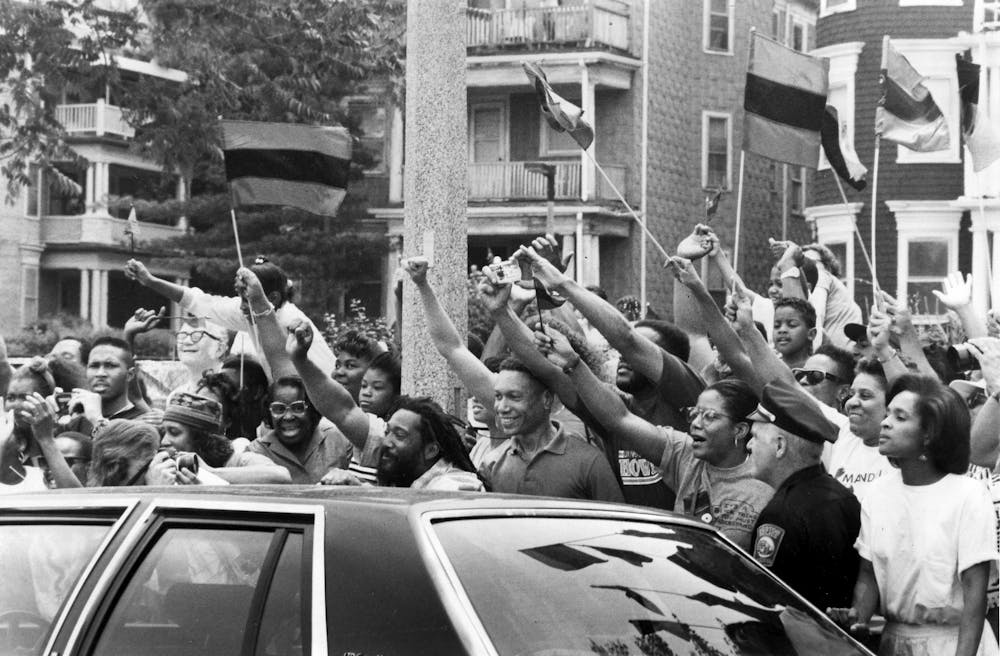 When South African civil rights icon Nelson Mandela visited Boston in 1990, his motorcade drove down King Boulevard through a crowd of well-wishers.
Mark Wilson/The Boston Globe via Getty Images[8]
When South African civil rights icon Nelson Mandela visited Boston in 1990, his motorcade drove down King Boulevard through a crowd of well-wishers.
Mark Wilson/The Boston Globe via Getty Images[8]
Most of America’s MLK neighborhoods, from east Montgomery[9], Alabama, to Harlem in New York City, were born of legal or de facto racial segregation[10]. And in the second half of the 20th century, they experienced the sharpest decline in urban industry, sending local jobs from the cities to suburbs.
These historic events first caused, then structurally perpetuated, deprivation in MLK neighborhoods. Concentrated urban poverty affected the funding required to support schools, hospitals and other community services[11], especially after the economic recession of the 1970s. In many cities, the sinking socioeconomic status of African Americans[12] was compounded by government neglect of their neighborhoods[13], leading to property devaluation, industrial pollution and disrepair.
The result is that MLK neighborhoods have become what Alderman calls a “racialized” landscape. Systematically ignored for investment and government services[14], they are now negatively stereotyped as marginal places where poverty, disorder, dereliction and crime are considered normal[15].
What other research is being done
Our study builds on Alderman’s 2000 investigation on MLK streets[16] by revealing that the neighborhoods around them are highly racially segregated.
But they are also vibrant commercial districts.
In 2007, geographer Matthew Mitchelson and co-authors[17] analyzed businesses on streets named after King, examining their numbers, annual sales and staff size. His study concluded these businesses are comparable in terms of revenue and jobs provided to those located on other commercial arteries – namely, Main Streets and streets named after President John F. Kennedy.
Mitchelson’s analysis also found that MLK streets have proportionally more churches and government offices than Main Streets or JFK streets.
What still isn’t known
Research on urban resilience[18] suggests the marginalization of MLK neighborhoods could make their residents more vulnerable to natural disasters and pandemics like the coronavirus[19], but this connection has yet to be studied.
Finally, the arrival of Latinos to MLK neighborhoods left us wondering: Will increasing diversity bring an end to the negative stereotyping of these areas – or simply change those stereotypes?
References
- ^ Research Brief (theconversation.com)
- ^ our recent study (doi.org)
- ^ GeoJournal (www.springer.com)
- ^ commemorate the civil rights movement and King’s fight against social inequality (www.taylorfrancis.com)
- ^ Grand Boulevard, in the historically Black South Side (www.dnainfo.com)
- ^ the University of Tennessee geographer Derek Alderman (doi.org)
- ^ Black America’s Main Street (www.abebooks.com)
- ^ Mark Wilson/The Boston Globe via Getty Images (www.gettyimages.com)
- ^ east Montgomery (www.montgomeryadvertiser.com)
- ^ legal or de facto racial segregation (www.jstor.org)
- ^ affected the funding required to support schools, hospitals and other community services (www.jstor.org)
- ^ sinking socioeconomic status of African Americans (sk.sagepub.com)
- ^ government neglect of their neighborhoods (doi.org)
- ^ investment and government services (www.bloomberg.com)
- ^ poverty, disorder, dereliction and crime are considered normal (doi.org)
- ^ Alderman’s 2000 investigation on MLK streets (doi.org)
- ^ Matthew Mitchelson and co-authors (www.jstor.org)
- ^ urban resilience (theconversation.com)
- ^ pandemics like the coronavirus (theconversation.com)
Authors: Sweta Tiwari, Post Doctoral Fellow in Geospatial Institute, Saint Louis University