

Why the earth quakes – a closer look at what's going on under the ground
- Written by Jaime Toro, Professor of Geology, West Virginia University
Earthquakes, large and small, happen every single day[1] along zones that wrap around the world like seams on a baseball. Most don’t bother anybody, so they don’t make the news. But every now and then a catastrophic earthquake hits people somewhere in the world with horrific destruction and immense suffering.
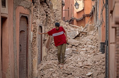
On Sept. 8, 2023, a magnitude 6.8 earthquake in the Atlas Mountains of Morocco shook ancient villages apart, leaving thousands of people dead[2] in the rubble. In February 2023, a large area of Turkey and Syria[3] was devastated by two major earthquakes that hit in close succession.
As a geologist[4], I study the forces that cause earthquakes. Here’s why some seismic zones are very active while others may be quiet for generations before the stress builds into a catastrophic event.
Earth’s crust crashes into itself and pulls apart
Earthquakes are part of the normal behavior of the Earth. They occur with the movement of the tectonic plates that form the outer layer of the planet[5].
You can think of the plates as a more or less rigid outer shell that has to shift to allow the Earth to give off its internal heat.
These plates carry the continents and the oceans, and they are continuously in slow-motion crashes[7] with one another. The cold and dense oceanic plates dive under continental plates and back into Earth’s mantle in a process known as subduction[8]. As an oceanic plate sinks, it drags everything behind it and opens a rift somewhere else that is filled by rising hot material from the mantle that then cools. These rifts are long chains of underwater volcanoes, known as mid-ocean ridges[9].
Earthquakes accompany both subduction and rifting. In fact, that is how the plate boundaries were first discovered.
In the 1950s, when a global seismic network was established[10] to monitor nuclear tests, geophysicists noticed that most earthquakes occur along relatively narrow bands that either fringe the edges of ocean basins, as in the Pacific, or cut right down the middle of basins, as in the Atlantic[11].
They also noticed that earthquakes along subduction zones are shallow on the oceanic side but get deeper under the continent[12]. If you plot the earthquakes in 3D, they define slablike features that trace the plates sinking into the mantle.
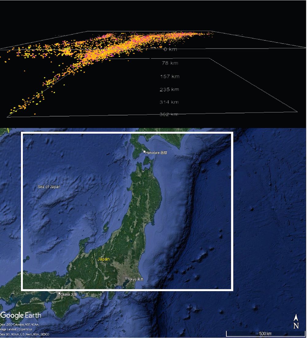 Ten thousand earthquake locations from 1980 to 2009 trace the Pacific Plate as it subducts under northern Japan. The top image is a side view showing the depth of the earthquakes beneath the rectangle on the map.
Jaime Toro, CC BY-ND[13]
Ten thousand earthquake locations from 1980 to 2009 trace the Pacific Plate as it subducts under northern Japan. The top image is a side view showing the depth of the earthquakes beneath the rectangle on the map.
Jaime Toro, CC BY-ND[13]
An experiment: How an earthquake works
To understand what happens during an earthquake, put the palms of your hands together and press with some force. You are modeling a plate boundary fault. Each hand is one plate, and the surface of your hands is the fault. Your muscles are the plate tectonic system.
Now, add some forward force to your right hand. You will find that it will eventually jerk forward when the forward force overcomes the friction between your palms. That sudden forward jerk is the earthquake.
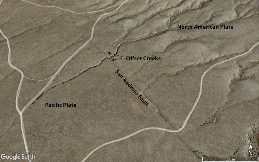 A Google Earth image of creeks offset by movement along the San Andreas fault in southern California as the Pacific Plate moves to the northwest with respect to North America.
Jaime Toro[14]
A Google Earth image of creeks offset by movement along the San Andreas fault in southern California as the Pacific Plate moves to the northwest with respect to North America.
Jaime Toro[14]
Scientists explain earthquakes using what’s known as the elastic rebound theory[15].
Fast plates move at up to 8 inches (20 centimeters) per year, driven mostly by the oceanic slabs sinking at subduction zones. Over time, they become stuck to each other by friction at the plate boundary. The attempted motion deforms the plate boundary zone elastically, like a loaded spring. At some point, the accumulated elastic energy overcomes the friction and the plate jerks forward, causing an earthquake.
But the plate-driving forces[16] do not stop, so the plate boundary starts to accumulate elastic energy again, which will cause another earthquake – perhaps soon or perhaps far in the future.
In the oceans, plate boundaries are narrow and well defined because the underlying rocks are very stiff. But within the continents, plate boundaries are often broad zones of deformed mountainous terrain crisscrossed by many faults. Those faults may persist for eons, even if the plate boundary becomes inactive. That is why sometimes earthquakes occur far from plate boundaries.
Earthquakes, fast and slow
The cyclic behavior of faults allows seismologists to estimate earthquake risks statistically[17]. Plate boundaries with fast motions, such as the ones along the Pacific rim, accumulate elastic energy rapidly and have the potential for frequent large-magnitude earthquakes.
Slow-moving plate boundary faults take longer to reach a critical state. Along some faults, hundreds or even thousands of years can pass between large earthquakes. This allows time for towns to grow and for people to lose ancestral memory of past earthquakes.
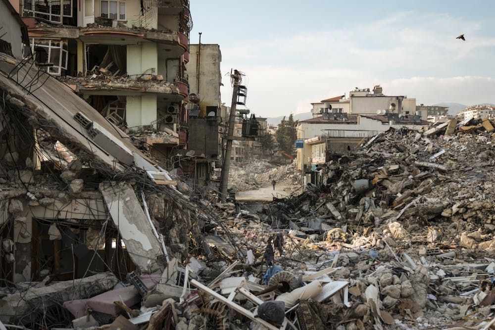 A magnitude 7.8 earthquake that hit Syria and Turkey on Feb. 9, 2023, destroyed buildings and killed more than 50,000 people.
Mehmet Kacmaz/Getty Images[18]
A magnitude 7.8 earthquake that hit Syria and Turkey on Feb. 9, 2023, destroyed buildings and killed more than 50,000 people.
Mehmet Kacmaz/Getty Images[18]
The earthquake in Morocco is an example. Morocco is located on the boundary between the African and the Eurasian plates[19], which are slowly crashing into each other.
The huge belt of mountains that extends from the Atlas of North Africa to the Pyrenees, Alps and most of the mountains across southern Europe and the Middle East is the product of this plate collision. Yet because these plate motions are slow near Morocco, large earthquakes are not so frequent.
Preparing for the big one
An important fact about catastrophic earthquakes is that, in most cases, the earthquakes don’t kill people – falling buildings do.
Most Americans have heard of California’s San Andreas Fault[20] and the seismic risk to San Francisco and Los Angeles. The last major earthquake along the San Andreas Fault hit at Loma Prieta[21], in the San Francisco Bay area, in 1989. Its magnitude, 6.9, was comparable to that of the earthquake in Morocco, yet 63 people died compared with thousands. That’s largely because building codes in these earthquake-prone U.S. cities are now designed to keep structures standing when the Earth shakes.
The exceptions are tsunamis[22], the huge waves generated when an earthquake shifts the seafloor, displacing the water above it. A tsunami that hit Japan in 2011[23] had horrific consequences, regardless of the quality of engineering in coastal towns.
Unfortunately, earthquake scientists can’t predict exactly when[24] an earthquake might occur; they can only estimate the hazard.
References
- ^ happen every single day (earthquake.usgs.gov)
- ^ thousands of people dead (www.cbsnews.com)
- ^ Turkey and Syria (www.dw.com)
- ^ a geologist (scholar.google.com)
- ^ outer layer of the planet (www.usgs.gov)
- ^ USGS/GMRT (www.usgs.gov)
- ^ slow-motion crashes (oceanexplorer.noaa.gov)
- ^ known as subduction (youtu.be)
- ^ mid-ocean ridges (oceanexplorer.noaa.gov)
- ^ global seismic network was established (www.ldeo.columbia.edu)
- ^ as in the Atlantic (www.geolsoc.org.uk)
- ^ get deeper under the continent (www.mheducation.com)
- ^ CC BY-ND (creativecommons.org)
- ^ Jaime Toro (earth.google.com)
- ^ elastic rebound theory (earthquake.usgs.gov)
- ^ plate-driving forces (oceanservice.noaa.gov)
- ^ estimate earthquake risks statistically (www.usgs.gov)
- ^ Mehmet Kacmaz/Getty Images (www.gettyimages.com)
- ^ between the African and the Eurasian plates (www.youtube.com)
- ^ California’s San Andreas Fault (www.nytimes.com)
- ^ hit at Loma Prieta (www.conservation.ca.gov)
- ^ exceptions are tsunamis (www.youtube.com)
- ^ Japan in 2011 (www.ncei.noaa.gov)
- ^ can’t predict exactly when (theconversation.com)
Authors: Jaime Toro, Professor of Geology, West Virginia University